CONSERVATION VISION FOR WINONA’S 2018 COMPREHENSIVE PARKS AND RECREATION SYSTEM PLAN
Submitted by
THE CONSERVATION COMMITTEE OF THE WINONA BIRD CLUB
September 4, 2018
Roberta Bumann Helen Davis Tex Hawkins
Dr. Carol Jefferson Lorraine Kilmartin Scott Lowery Todd Paddock
Kathleen and David Palmquist Matthew Schultz
Richie Swanson Barbi Bell
Contact: Richie Swanson, President, Winona Bird Club, richieswan201@gmail.com
TABLE OF CONTENTS
OVERALL CONSERVATION VISION FOR WINONA’S PARKS……….. 1
VISION FOR PRAIRIE ISLAND…………………………………………………………… 2
Recommendations Background
Floodplain Forest
Sand Prairie, Nature Trail Campground and Kiwanis Shelter
Sources
VISION FOR WINONA’S BLUFF LANDS……………………………………………. 5
Recommendations Background
Rock and Cliff Sites Rare Habitat Cultural Resources
Sources
VISION FOR AGHAMING PARK: A JOHH LATSCH PRESERVE…….. 8
Recommendations Background
Winter Access Road Bald Eagle Nests
Mowing and Garlic Mustard Nature-based Names
Sources
VISION FOR LAKE PARK………………………………………………………………… 12
Recommendations Background Sources
APPENDIX:
The City of Madison 2012-2017 Park and Open Spaces Places…………………….. 13
Overall Conservation Vision for Winona’s Parks
The Conservation Vision Committee of the Winona Bird Club commends the city’s trail efforts, Garvin Heights and Sugar Loaf restorations, Healthy Lake Winona and the city’s lease agreement with the Upper Mississippi River National Wildlife and Fish Refuge to cooperatively manage Aghaming Park: A John Latsch Preserve.
We champion efforts and partnerships that protect the city’s natural landscapes and that cherish the Mississippi River’s migratory bird flyway, and our bluff lands, native prairie remnants, wetlands, waterways, and other ecosystems of the Driftless Area.
As the city develops trails and other recreational opportunities, science and community engagement must find the courage and knowledge to say no to inappropriate development, so access does not compromise nature. Winona shortchanges future generations if we convenience ourselves with the illusion that outdoor recreation and recreational use of landscape alone will conserve natural resources.
Our committee encourages the city to cultivate reverence for the nature that occurs in its parks. We envision a parks system that reflects an appreciation for ecosystems in their own right as well as for the benefits they provide humanity: clean air and water, healthy soil, the natural storage of carbon, inspiration, and recreational and economic opportunities.
We encourage the city to protect opportunities for wildlife watchers, who contributed
75.9 billion dollars to the US economy in 2016. ((U.S. Dept. of Interior et. al. 2016).
We envision a park system that balances recreational opportunities with conservation plans that:
- Leave nature undisturbed at particular times and places, so natural resources can sustain
- Include searches for threatened and endangered species.
- Identify and protect rare
- Restore biodiversity where it has previously been
- Create large blocks of natural and protected areas to complement areas of activity. Designate conservation parks.
- Protect sandstone and dolomite bluffs from all human disturbance, including the disturbance of ice-climbing
- Protect wetlands from development and inappropriate
- Teach and celebrate conservation by example and educational
Sources
U.S. Department of the Interior, U.S. Fish and Wildlife Service, and U.S. Department of Commerce, U.S. Census Bureau. 2016 National Survey of Fishing, Hunting, and Wildlife-associated Recreation.
Vision for Prairie Island
Winona can celebrate and publicize forest and prairie restorations at Prairie Island and use them as educational tools. As the city strives to become a regional recreation center, it can balance recreational land-use with conservation achievements that store carbon in soil and vegetation, and enable people to grow closer to nature and appreciate her value to people.
Recommendations for Prairie Island
Create conservation designations that ensure no further loss or degradation of natural habitat.
Manage the Nature Trail and Deer Park as a solid block of floodplain forest, as contiguous and un-fragmented habitat. Encourage oak and other forest regeneration.
Manage/restore the remaining sand prairie that exists between the Dog Park and the land and prairie owned by U.S. Fish and Wildlife, perhaps in cooperation with USFWS.
Develop a new interpretive trail brochure and other educational resources and activities to connect the public to nature.
Reduce mowing and allow autumn’s herbaceous growth to remain as winter habitat.
Allow shrubs to revegetate in denuded areas, and create structural as well as plant diversity.
Remove exotic and invasive species. Sequester carbon with habitat restoration. Recognize historical loss of habitat/nature.
Require staff to refer to Minnesota’s Environmental Assessment Worksheet and Division Resource Assessment Record for any recreational or other development in natural habitat.
Background
Floodplain Forest
Floodplain forest appears abundant in the Winona area, thanks to the Upper Mississippi River National Wildlife and Fish Refuge. But outside the refuge, the upper river’s floodplain forest has been significantly reduced since European settlement, and contiguous forest is primarily confined to a “relatively narrow strip on the riverward side” of levees (Guyon et. al. 2012).
Tree species diversity in general is declining inside the altered hydrology of the lock and dam system. Mast-producing trees (oaks and hickories) struggle to regenerate in the floodplain (Guyon et. al. 2016). But the Deer Park currently supports oaks. If the city ever decides to manage the area differently (e.g. remove the fences and deer), reforestation of mast-producing trees can increase tree diversity alongside the lower, wetter floodplain forest adjacent to the Deer Park. Wildlife and vegetation will benefit from an increase of contiguous habitat and natural corridors. Human visitors will continue to enjoy experiences like seeing 20 warbler species at one place in a single day, a rare pleasure in the bird-tourist world. Restoration will expose people to greater diversity.
Healthy floodplain forests improve water quality. “Although forest regeneration alone will not solve water quality issues, it will greatly improve the ecosystem’s natural ability to remove toxins, nutrients, and sediments from the Upper Mississippi River System, thereby creating a more sustainable system.” (Guyon et. al. 2012).
Floodplain forests sequester carbon, mitigating climate change. They improve fish habitat. Floodplain forests and other habitats in the Upper Mississippi’s floodplain support 300 bird species. The floodplain has been designated as a globally important flyway for 60 percent of all bird species in North America, including 40 percent of the nation’s waterfowl and shorebirds. The floodplain’s ecosystems support 57 mammal species, 150 fish species, 50 mussel species and 45 species of amphibians and reptiles (Guyon et. al. 2016, National Audubon Society 2013).
Floodplain habitat is crucial to “286 State-listed or candidate species and 36 Federally-listed or candidate species of rare, threatened or endangered plants and animals endemic to the Upper Mississippi River Basin.” (Guyon et. al. 2012).
Sand Prairie, Nature Trail
In 1986 the Winona Bird Club (formerly the Hiawatha Valley Audubon Society) worked with the city, local universities, the Southeastern Minnesota Initiative Fund and other organizations to create the Prairie Island Nature Trail, an interpretive trail brochure and the Prairie Island Environmental Education Curriculum Guide used by many classes. The club also helped maintain a sand prairie, much of which has been lost to the city’s Dog Park, a wetlands mitigation and other disturbances.
Unfortunately, nearly 99 percent of Minnesota’s prairie has been lost since the Public Land Survey of 1847-1908 (Minnesota Prairie Plan Working Group 2011).
Prairie loss diminishes the natural erosion and flood control, pollution control and detoxification, and nutrient recycling of deep-rooted prairie plants. Prairies keep carbon in the ground rather than in the atmosphere and store more carbon in soil than even forests do above ground (Schwarz March 4, 2014, Shaw June 27, 2011).
Species losses at Prairie Island include the virtual disappearance or dramatic decline of red-headed woodpeckers, eastern meadowlarks, common nighthawks (which once occurred in nearly uncountable numbers above the river and adjacent habitats during evenings, May-September), black terns, and American woodcocks (which once performed sky-dances numerously in scrub habitat). (Richie Swanson pers. ob.).
The loss of the prairie also means the loss of prairie smoke, prairie wild rose, prairie blazing star, coneflowers, indigo and other pollinator plants.
Winona shortchanges future generations if we allow these losses to go unrecognized and deprive the future of the knowledge of previous diversities.
Campground and Kiwanis Shelter
Prairie Island Campground provides easy access to trails in rare habitats. The city can enhance campers’ experience of the river and habitats by seeking funds for a seasonal naturalist and promoting educational activities.
The campground and area around the Kiwanis Shelter can reduce the monoculture of lawn-like grasses by planting buttonbush and other shrubs native to the floodplain.
Shrubs make campsites more private and attractive. Trees planted should be a variety of suitable native species protected with mulch, fencing and tree tubes.
Sources
Guyon, L., C. Deutsch, J. Lundh, and R. Urich 2012. Upper Mississippi River Systemic Forest Stewardship Plan. U.S. Army Corp of Engineers. 124 pp.
Guyon, L., J. Sloan, R. Van Essen, and M. Corcoran July 2016. Floodplain Forests and Water Quality in the Upper Mississippi River System. Report to the Audubon Society. Natural Great Rivers Research and Education Center, Lewis and Clark Community College.
Environmental Education Committee, Hiawatha Valley Audubon Club 1986. Prairie Island. Environmental Education Curriculum Guide.
Minnesota Prairie Plan Working Group 2011. Minnesota Prairie Conservation Plan. Minnesota Prairie Plan Working Group, Minneapolis MN.
National Audubon Society 2013. Important Bird Areas in the U.S. https://www.audubon.org/important–bird-areas/upper-mississippi-river-nwr-iba.
Schwarz, Judith D. March 4, 2011. Soil as Carbon Storehouse: A New Weapon in Climate Fight? Yale Environment 360.
Shaw, Tina. June 27, 2011. Iowa: the Power of Prairies. Open Spaces. United States Fish and Wildlife Service Home Page.
Vision for Winona’s bluff lands
“To protect and perpetuate the diverse, natural, scenic, and cultural resources of the bluff-land landscape for low impact use, enjoyment and education of people today and for future generations.”–Great River Bluffs State Park Management Plan
Recommendations
Create conservation designations that protect sandstone and dolomite cliffs from disturbance and development of all kinds.
Recognize that the current ice-climbing wall disturbs winter habitat that has a high potential to support endangered resources.
Develop ice-climbing walls and other climbing opportunities elsewhere.
Work with the Minnesota Biological Survey to identify historical sites of dry bluff prairies, dry cliff prairies and other rare plant communities owned by the City of Winona. Create conservation and restoration plans for the sites.
Amend the city bluff ordinance to protect bluffs from ice farming and all climbing activities.
Prioritize specific local habitat, inventories of natural resources, and removal and control of invasive species in trail plans. Search for algific slopes.
Adopt habitat-specific conservation goals in regard to bicycle and other trails. Create natural areas to mitigate disturbance.
Create natural areas in large blocks, as contiguous rather than fragmented habitat.
Require staff to refer to Minnesota’s Environmental Assessment Worksheet and Division Resource Assessment Record for any recreational or other development in natural habitat.
Preserve cultural resources of the Dakota Indians.
Background
Our vision for Winona’s bluff lands is quoted directly from the Great River Bluffs State Park Management Plan (Minnesota DNR Division of Parks and Recreation 2005). The plan is apt to Winona’s bluff lands, since the park and Winona’s bluffs share Driftless Area geology, and natural histories are similar.
GRBSP’s plan designates dolomite and sandstone cliffs as “high priority areas for protection from disturbance or development of any kind.” (Minnesota DNR Division of Parks and Recreation 2005).
5
Rock and Cliff Sites
Winona’s ice-climbing wall creates an unnatural barrier for the movement of winter wildlife. It seals off potential den sites for endangered snakes. It blocks views of the natural rock. It prevents basking and foraging activities of wildlife. A peregrine falcon will never investigate a cliff covered with an ice wall in March for a nest site.
Winona’s ice-climbing wall adds additional ice to its cliff and delays the natural timeline of spring thaw and related spring processes. The additional ice may add to risks of erosion during spring thaw, adding extra water to any washouts of sand that impact plants and habitat. Shelf rock may break and fall from cliffs prematurely, due to the thaw of the unnatural concentration of ice.
The current ice-climbing wall may exist near indications of an algific slope (Dr. Carol Jefferson, pers. com.). If Winona moves the ice-climbing wall to a less sensitive
location, completely away from natural rock, the city eliminates the wall’s risks to the cliff and its environs.
Dakota County received $800,000 through two grants from the Conservation Partners Legacy Program for bluff and other prairie restoration that began in 2017. Similar grants could be available to Winona. But a proposal would have to compete with others that are free of the unnatural intrusion of an ice-climbing wall in winter habitat.
Proposals for cliff-prairie restorations that do not involve ice-climbing walls show a stronger commitment to conservation. They do not include the intrusion in winter habitat, nor the risks of damage to cliffs related to an unnatural addition of ice, changes in natural freeze-thaw cycles and erosion.
Rock and cliff sites are crucial habitat all year long in a greater ecosystem that includes wildlife as well as humans. Peregrine falcons (state-threatened) investigate cliff-nest sites in late winter, and cliffs serve as winter dens for timber rattlesnake (state-threatened), racer and gopher snakes (state-special-concern).
Rare Habitat
GRBSP’s plan protects rare plant communities, including the state-endangered flower discovered by J.M. Holzinger in 1889, Montia Chamissoi, and the state-threatened Sullivant’s coolwort. Other endangered plants that may someday be found or restored on Winona’s bluff prairies include white lady’s slipper, cliff goldenrod, creeping juniper and silverleaf grape.
Winona’s bluff lands may include one of the rarest habitats on Earth, Southern Algific Talus–as indicated by geology, ice-water seeps and previous presence of mountain maple, yellow birch and Canada yew (Dr. Carol Jefferson, pers. com.).
The Minnesota Biological Survey identified cliff and forest sites at or very near Bluffside Park to have “High Diversity Significance…containing occurrences of the rarest species” and “landscapes of strong potential for recovery.” (MBS email com.) The city can obtain a data use agreement from MBS to obtain rare species data and GIS shapefiles of native plant communities and Sites of Biodiversity Significance
from the Minnesota Geospatial Commons. The info is free for government entities. (MBS email com.).
Winona’s bluff-lands constitute a rare reservoir for forest birds and neo-tropical migrants who face habitat degradation and contamination all along their journeys from South and Central America. At least 15 of the Bird Species of Greatest Conservation Need listed in Minnesota’s Wildlife Action Plan 2015-2025 use upland forests (e.g. red-headed woodpecker, wood thrush, yellow-billed cuckoo, black-billed cuckoo, winter wren, cerulean warbler). (Richie Swanson pers. info. Breeding Bird Census data.)
The success of breeding birds can be impaired if too many bicycles flush birds and reveal nest sites to predators or disrupt food-gathering for young or migrations. The creation of large blocks of undisturbed woods, natural areas or conservation parks, helps mitigate such disturbance.
The City of La Crosse has a Restoration and Land Management program that includes projects to help create habitat for pollinators such as Monarchs and Rusty Patch bumble bees (federal-endangered). Winona’s public lands give our community the same opportunity.
Cultural Resources
Dakota Indians regard mounds and Spirit Cave at Bluffside Park as sacred (Dr. Carol Jefferson, pers. com.). The city should seek appropriate protection.
Sources
Audubon Minnesota Spring 2014. Cerulean Warbler Minnesota Conservation Plan.
https://www.co.dakota.mn.us/parks/Improvement/Pages/miesville-ravine-bluff- prairie-restoration.aspx
https://www.dnr.state.mn.us/eco/mcbs/maps.html https://www.richieswanson.com/index.php/breeding-bird-census
Jefferson, Carol Ph.D. Plant ecologist and Professor Emeritus of Biology at Winona State University.
Minnesota Department of Natural Resources Division of Parks and Recreation 2005. Great River Bluffs State Park Management Plan.
Minnesota Department of Natural Resources 2016. Minnesota’s Wildlife Action Plan 2015-2025. Division of Ecological and Water Resources, Minnesota Department of Natural Resources.
Vision for Aghaming Park: A John Latsch Preserve
“The Upper Mississippi River National Wildlife and Fish Refuge is beautiful, healthy, and supports abundant and diverse native fish, wildlife, and plants for the enjoyment and thoughtful use of current and future generations.”–2006 Upper Mississippi River National Wildlife and Fish Refuge Comprehensive Conservation Plan
Recommendations
Implement the city’s lease agreement with the U.S. Fish and Wildlife Service “for the purpose of managing the unique fish and wildlife habitats” of Aghaming.
Recognize and address wetland damage related to the winter access road.
Cultivate science and nature appreciation by responsibly monitoring bald eagles.
Encourage native vegetation to grow on the borders of the old cement road/future bicycle trail.
Enable native vegetation to grow free of the disturbance of motorized vehicles.
Adopt nature-based names for areas as suggested in 2005 Aghaming Park Trail System Plan. Create a “Swamp White Oak Reserve.”
Background
City Lease Agreement with U.S. Fish and Wildlife Service
The lease states that Aghaming “represents a historical connection to the Upper Mississippi River National Wildlife and Fish Refuge due to its connection with philanthropist John Latsch and conservationist Will Dilg who were instrumental in creating both public areas” (Lease March 27, 2018). Therefore our vision for Aghaming is quoted from the 2006 Upper Mississippi River National Wildlife and Fish Refuge Comprehensive Conservation Plan.
The agreement recognizes that Aghaming’s “acreage were classified as the highest value fish and wildlife habitat and is considered unique and irreplaceable on a national basis, within the ecoregion, and in the 2006 Upper Mississippi River
National Wildlife and Fish Refuge Comprehensive Conservation Plan” (Lease March 27, 2018).
Winter Access Road
The winter access road has increased damage of wetland soil, the forest floor and riparian banks at Aghaming. Motorized vehicles deepen ruts in the wetland soil of the old river road. They have forged parking spaces and pioneered rutted roads in swamp white oak habitat near the dilapidated cement bridge that terminates winter vehicle access. Vehicles access frozen sloughs via banks, compacting soil. Vehicles also drive across islands and through winter vegetation. They create ruts in wetland soil on
islands, further degrading swamp white oak habitat (Richie Swanson, pers. ob.)
When the Wisconsin DNR discussed the winter road with the City of Winona in 2009, it told the city it must place “barriers at key points where vehicles are leaving the road” and “signs to instruct users how the road should be used.” (Pericak, D. May 8, 2009.) Currently jersey barriers close the road effectively March 1 to October 31 and protect the natural habitat downriver from the barriers. However motorized vehicles access the road November 1 to February 28, and no barriers are in place. No signs instruct drivers alongside the sensitive wetlands of the road. Nine years after the Wisconsin DNR warned that the road needed an adequate plan, wetland degradation by motorized vehicles continues (Richie Swanson, pers. ob.).
The city might designate a “Swamp White Oak Reserve.” See Nature-based Names below.
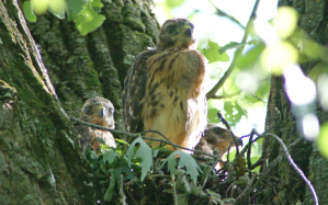
Bald Eagle Nests
Aghaming supports at least three bald eagle nests that could be monitored yearly by university students. Observations of an hour or more per week should be made from at least 330 feet to minimize disturbance. Observations from late January to the end of the academic year in May would likely document nest establishment, nest defense, conflicts with ospreys and other eagles, onset of incubation, food visits to nestlings and appearance of eaglets over nest rim. Info can be reported to the National Eagle Center, Upper Mississippi River National Wildlife and Fish Refuge and E-bird etc.
Aghaming’s eagle nests are conspicuous and easy to find during winter. Students can access them by walking on ice, the old river road and by paddling in current-free backwaters. Students would be immersed in river habitat and seasonal changes.
Students could also count eagles at Aghaming during migration. (Richie Swanson, pers. ob.)
Mowing and Garlic Mustard
When the borders of the old cement road are mowed, garlic mustard invades the borders and follows remnant tire ruts and other disturbances in the forest floor into the woods. When the border is not mowed, nettles outcompetes garlic mustard. (Richie Swanson, pers. ob.)
Nature-based Names
The 2005 Aghaming Park Trail System Plan designated specific areas of the park as “Osprey Marsh,” “Prothonotary Lane (Trail),” “Soft Shell Slough,” and “Swamp White Oak Trail” (Barr Engineering 2005).
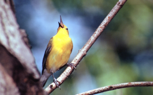
Osprey Marsh was the first place ospreys nested at Aghaming after the species’ recovery from population declines related to DDT contamination (Swanson 1998). “Prothonotary” refers to the prothonotary warbler, a rare and declining species who uses Aghaming at high density (Swanson 1998). “Soft Shell” refers to turtle habitat.
“Swamp White Oak” is a tree species that grows hundreds-of-years-old at Aghaming (Dr. Carol Jefferson, pers. com.).
When Mississippi River Revival conducted interpretive walks at Aghaming, a second marsh was called “Red-shouldered Marsh,” a reference to a Wisconsin state- threatened hawk who forages the wetland (Richie Swanson pers. ob.).
Nature-based names instantly convey the natural diversity of John Latsch’s gift of Aghaming. They help achieve objectives in the Aghaming lease agreement: “an interest in land and water suitable for wildlife habitat and wildlife oriented education, recreation and public outreach” (Lease March 27, 2018). If the city were to designate habitat along the winter access road and elsewhere as a “Swamp White Oak Reserve,” it would give name recognition to the little-known ecosystem. A “reserve” sends a message of reverence and awareness, rather than damage by motorized vehicles.
Though people may not understand the full stories of nature-based names, their use can arouse curiosity and reinforce that Aghaming is “land and water suitable for wildlife habitat.” Nature-based names are unique and therefore memorable. They can draw wildlife-watching tourists to Aghaming.
Nature-based names also function like the passenger pigeon monument at Wyalusing State Park in Wisconsin. They remind people that humanity can cause the extinction of wildlife species.
Common nighthawks were once seen by the hundreds in Aghaming’s skies, now they have become virtually absent (Richie Swanson, pers. ob.). The Wisconsin state- threatened yellow-crowned night heron bred formerly at Aghaming (Barr Engineering 2005). The Wisconsin state-endangered black tern bred formerly at Osprey Marsh (Swanson 1998). Both species have disappeared from those areas. Yellow-headed blackbirds, red-headed woodpeckers and other species have also stopped using specific areas. (Richie Swanson, pers. ob.). Declining species like these tell a story of the perpetual challenge of stewardship.
Sources
Barr Engineering Company. Aghaming Park Trail System Plan. December 2005. https://www.fws.gov/midwest/MidwestBird/eaglepermits/baeatake/recreation.html
Lease agreement between the City of Winona, Minnesota and the U.S. Fish and Wildlife Service. Mark Peterson, Mayor, and Monica Hennessey Mohan, City Clerk. March 27, 2018.
Pericak, David M. David Pericak, Wisconsin DNR, to Keith Nelson, City of Winona Public Works. Letter. May 8, 2009.
Swanson, Richie. Breeding Birds of Aghaming Park, 1998. In Aghaming Park: A
Community Resource Plan. Resource Studies Center. St. Mary’s University of Minnesota. Winona, Minnesota. 1998.
United States Fish and Wildlife Service. 2006 Upper Mississippi River National Wildlife and Fish Refuge Comprehensive Conservation Plan.
Vision for Lake Park
“To engage the Winona area community in action that improves the health of Lake Winona and preserves it as a valued community resource. Lake Winona is a healthy natural environment that supports a variety of native species and provides recreational opportunities for all ages.”–Healthy Lake Winona
Recommendations
Control Reed’s canary grass and other invasive and exotic plants on the shores of the channelized creek west of West Lake Winona. Create habitat by planting native cottonwoods on both shorelines.
Create an interpretive sign that celebrates cottonwoods and the species’ role in Mississippi River ecology, Native American culture and the ability of tall trees to store carbon. Recognize the historical decline of native cottonwoods at Lake Park and in the floodplain in general.
Background
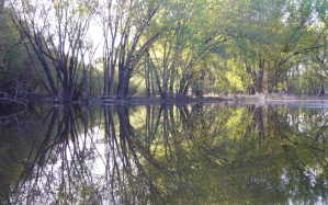
A niche of tall-tree habitat already exists on both shores of the channelized creek. But canary grass prevents regeneration as it does throughout the river’s floodplain.
The tall trees currently add a forest-like feel to the spur of the Lake Winona bicycle trail that runs from West Lake Winona to Vila Street. Additional tall trees may someday support a bald eagle nest in full view of Winona Senior High School.
Trees on the shores already provide natural cover for green herons, wood ducks and other wildlife. They provide habitat for northern orioles, American redstarts, great- crested flycatchers and other neo-tropical bird species.
The cerulean warbler, a Special Concern Species in Minnesota, prefers tall-tree habitat. The species sang for two consecutive breeding seasons in tall cottonwoods on East Lake Winona during the early 2000s.
The easy access of habitat along the bicycle trail from Vila Street could be promoted to wildlife watchers.
Sources
healthylakewinona.weebly.com
Swanson, Richie. Personal observations and field records.
Appendix
The City of Madison 2012-2017 Park and Open Spaces Plan
The Madison plan provides tools and ideas to integrate natural resource goals with recreational objectives in a municipal park system. We encourage the City of Winona to consult the plan as it strives to do the same. We recommend especially the creation and designation of conservation land, conservancy parks and natural areas.
The plan includes the preservation of “natural resources of land and water which provide the living quality and beauty” unique to the city (p. 3). Its vision recognizes natural resources alongside recreation (p. 5). Its mission recognizes affordable recreation and educational experiences but also natural area management and the preservation of urban forests (p. 5). It lists six ways to enhance and preserve “significant natural and cultural resources” (p. 6).
The Madison plan designates “land with natural integrity” as conservation land and conservancy parks, and it preserves “natural environment corridors” (p. 7). It preserves natural areas from intensive uses (p. 7). It defines types of parks and appropriate uses (p. 11).
Madison has created 14 conservation parks and continues to acquire conservation land (p. 12). It classifies specific uses of parks to integrate and meet all public needs (p.
29). It relied upon state-wide surveys and a state recreation plan to create the classifications (p. 40, p. 49).
Madison’s vision for its parks: “To provide the ideal system of parks, natural resources and recreational opportunities which will enhance the quality of life for everyone.” (p. 5).
Source